Janakpuri, Delhi
- GST NO. : 24AACCC7566J1ZG
QUADCOPTER

QUADCOPTER
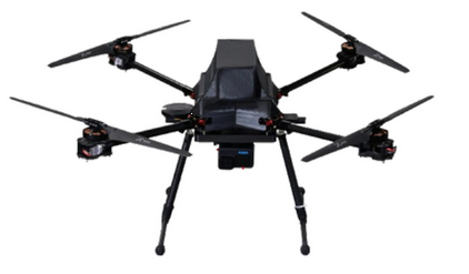
SURVEYING & MAPPING DRONE
Quadcopters improve the efficiency, accuracy, safety of surveying and mapping operations. Our drones are suitable for geo-tagging and geo-mapping applications, providing precise location information and aiding in creation of detailed maps.
- A light weight Quadcopter with multi payload support & extended range designed and developed especially for silent surveillance for long durations.
- Tried and tested at high altitudes.
Specifications
- High compact foldable design’Industrial level flight controller + GPS
- Simplified setup and flight operations with custom flight planning software
- High cruise speed of upto 54km/hr
- Very less operational noise
- Range of more than 10km
- Multicamera payload support
- Live streaming + Recording options
Safety features
- Safety switch
- Obstacle avoidance sensor
- Terrain RADAR sensor
- 128 BIT encryption
Return to Home feature On
- Low Battery
- High winds
- Radio fails
- GCS connection breaks
Efficiency
- Almost 1 hour of flight time
Flight modes
- Autonomous
- Semi-autonomous
- Manual
Applications
- Surveying & mapping
- Disaster management
- Search and Rescue operations
- Surveillance
- Inspection and maintenance

